BLACK MOUNTAIN 2010-2012
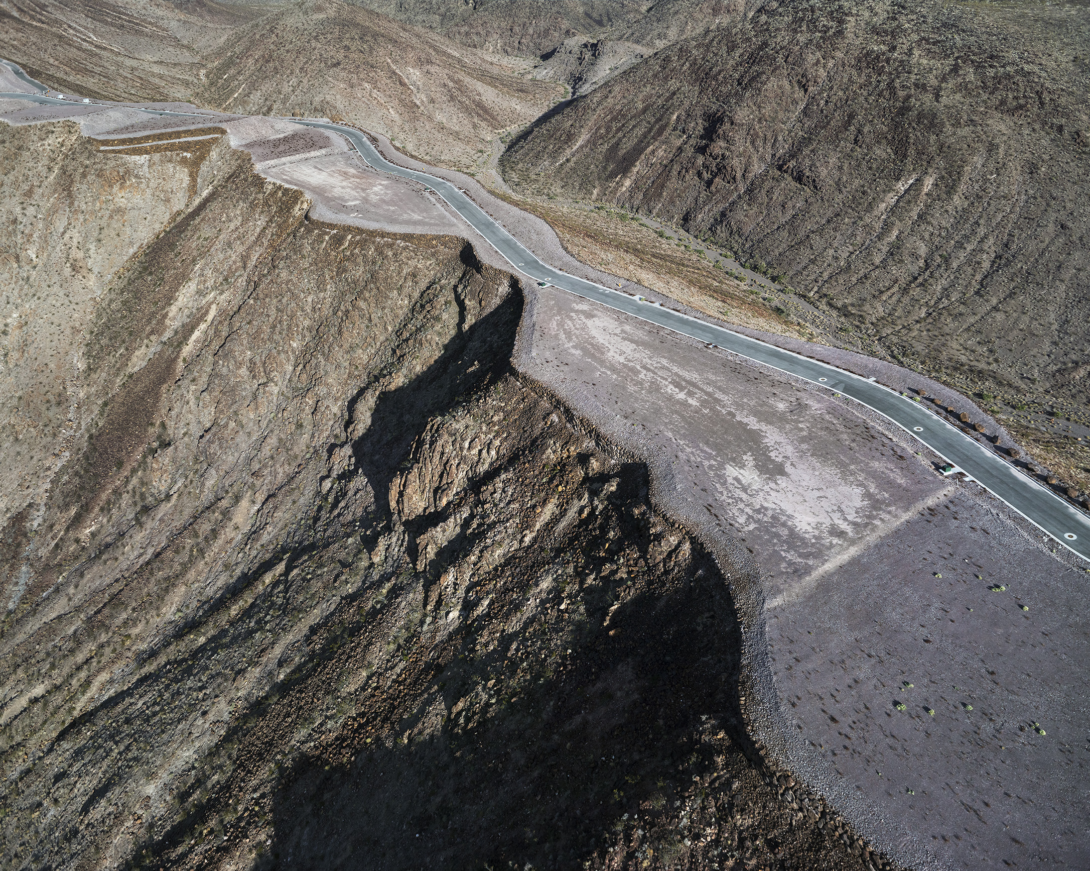
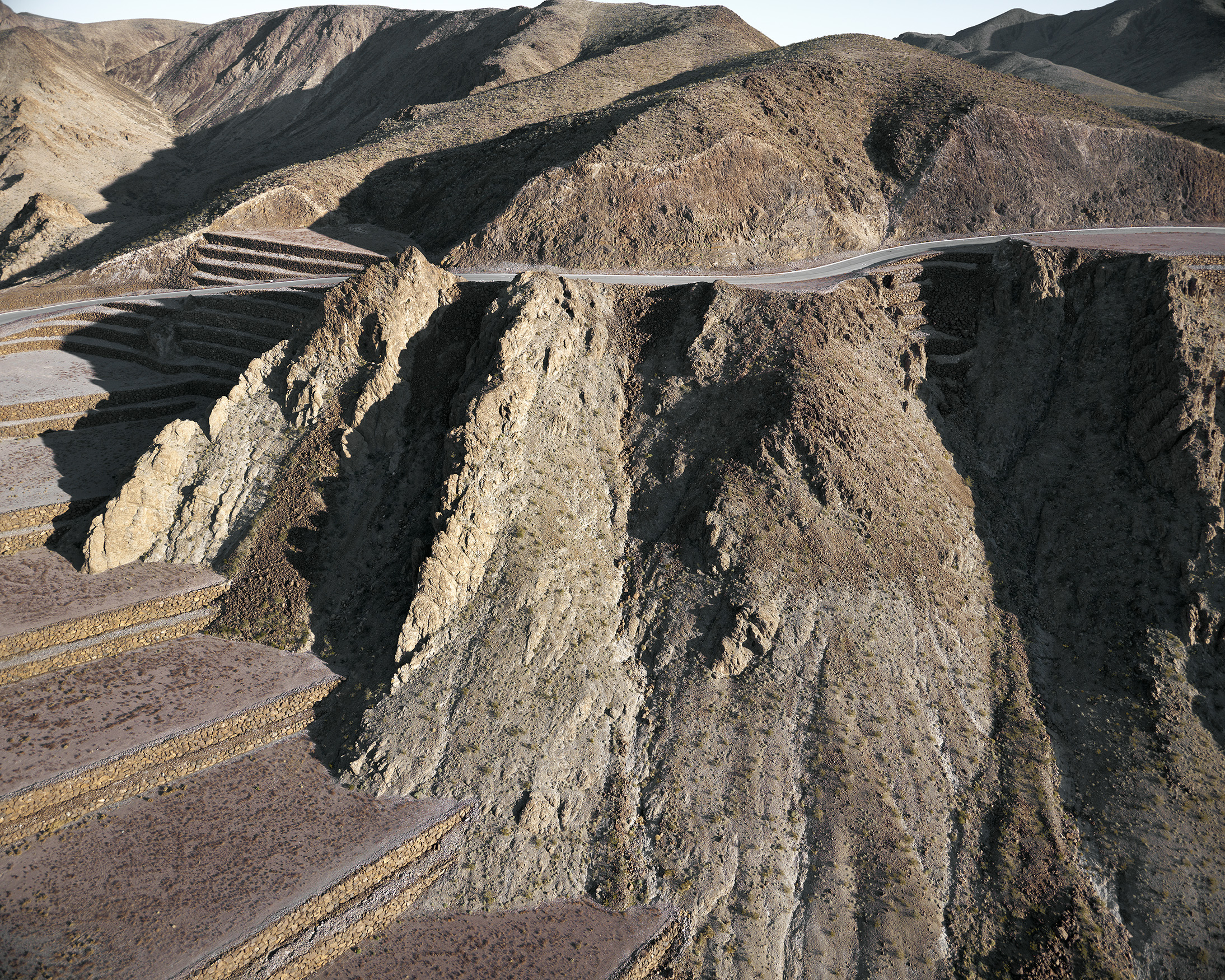
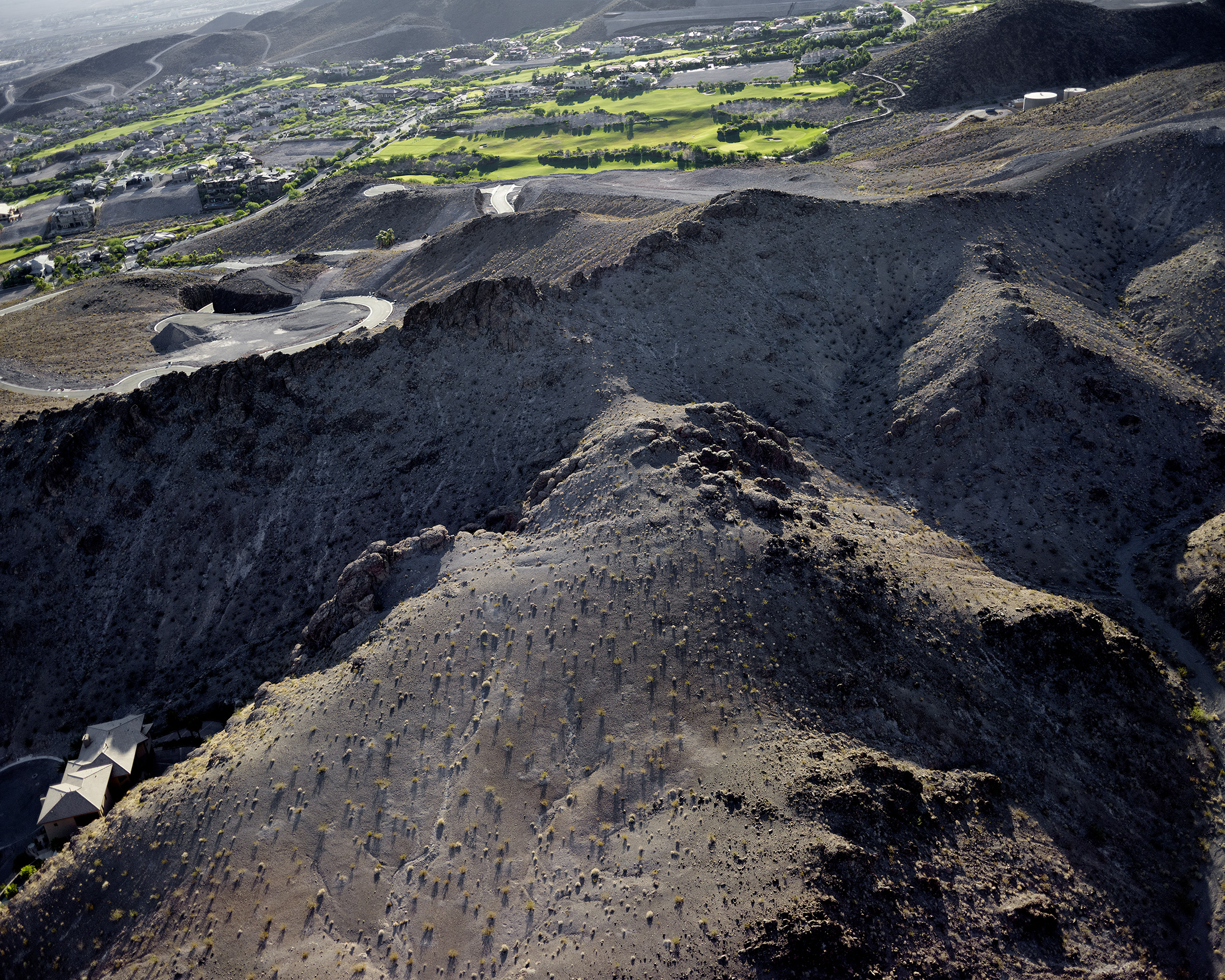
The northernmost peak of the McCullough Range, Black Mountain, looms 5100 feet over a geologically typical Nevada basin 3000 feet below. The mountain has been popular for a long time: it’s graced with 318 prehistoric rock art panels showing some 1700 individual petroglyphs. Recently it became part of the 48,000-acre Sloan Canyon National Conservation area; a little less recently the basin below became the fastest growing city in the United States. Most recently, since 2008 and the worst American economic downturn since the Great Depression, Las Vegas has suffered the highest unemployment and home foreclosure rate in the nation. Emptied of people, it has frozen at exactly the point where its aspirational excesses were most baroque and unfettered. Las Vegas is the epicenter of a classically American strain of boom and bust capitalism. Historically the Silver State has always veered between the excess and collapse of the extractive mining industry, but air-conditioning, proximity to California, and the retirement lifestyle have brought another economy to Nevada that operates on the same maniacal principles: the habitation industry. In terms of their physical effect on the land, the extraction and habitation economies are two sides of the same coin.
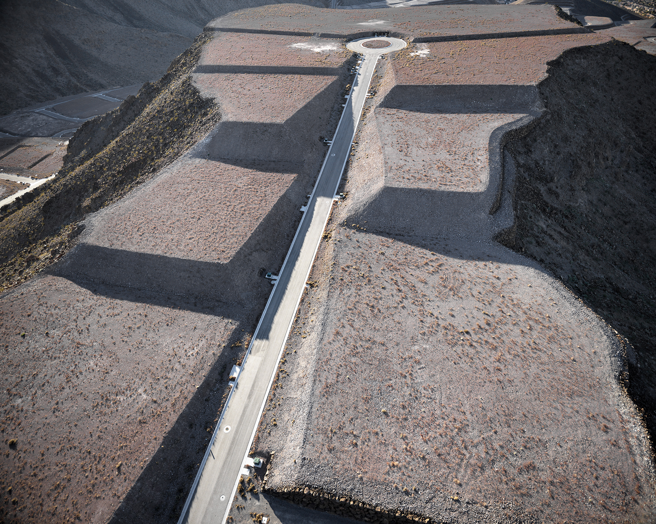
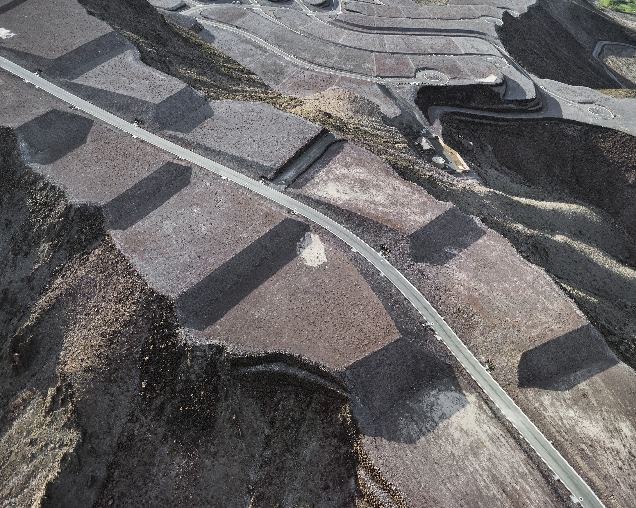
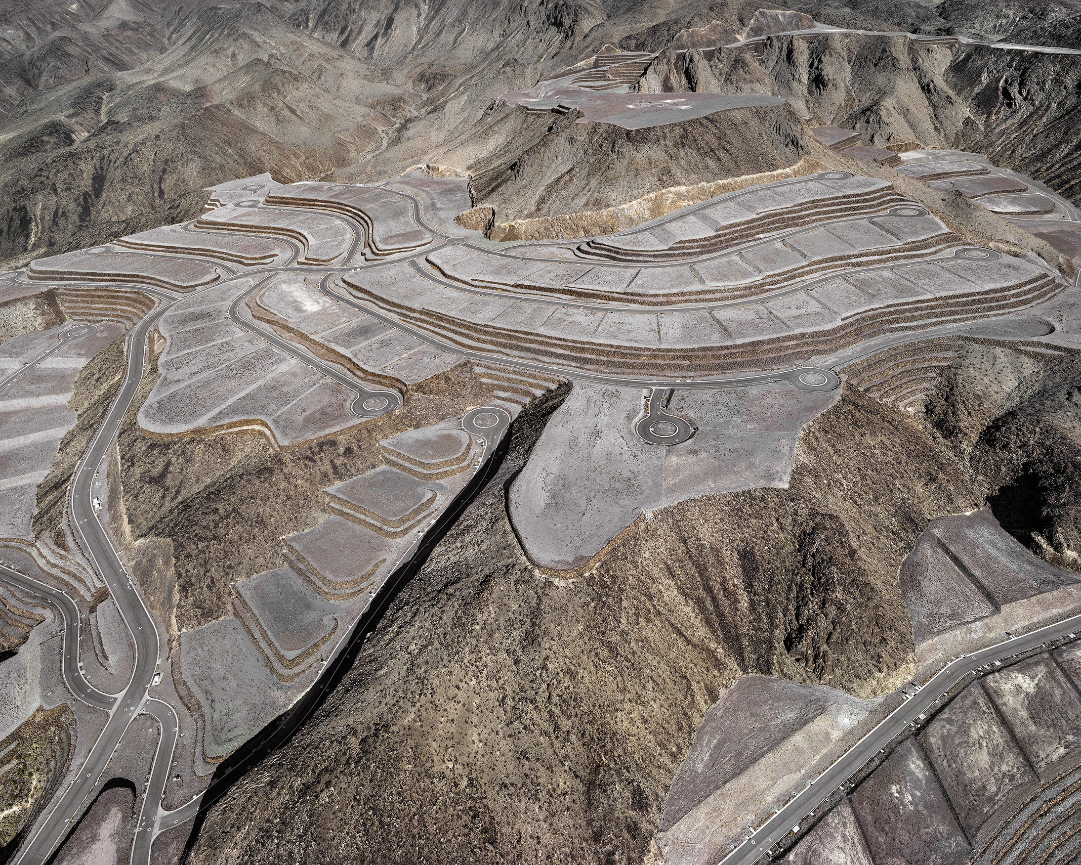
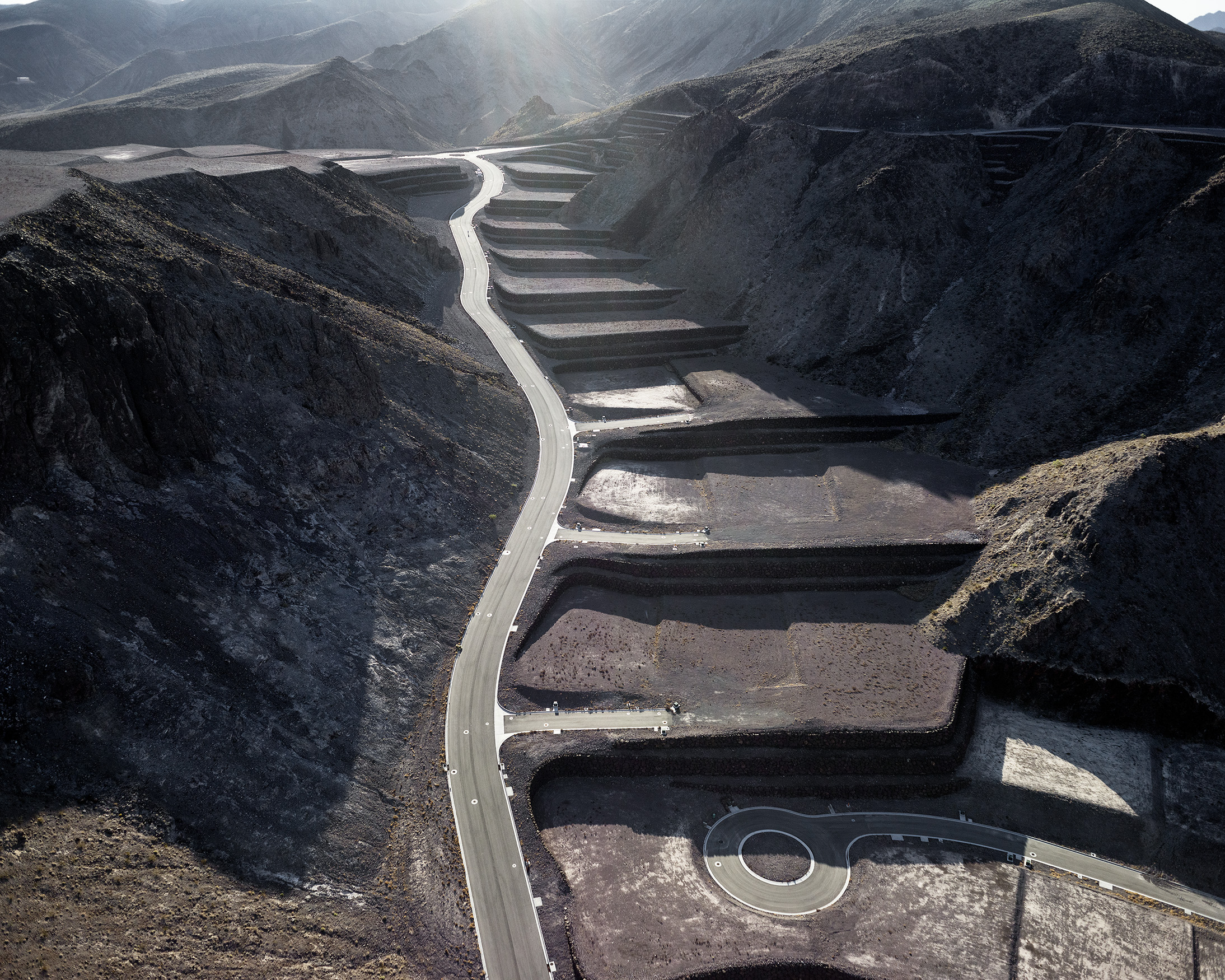
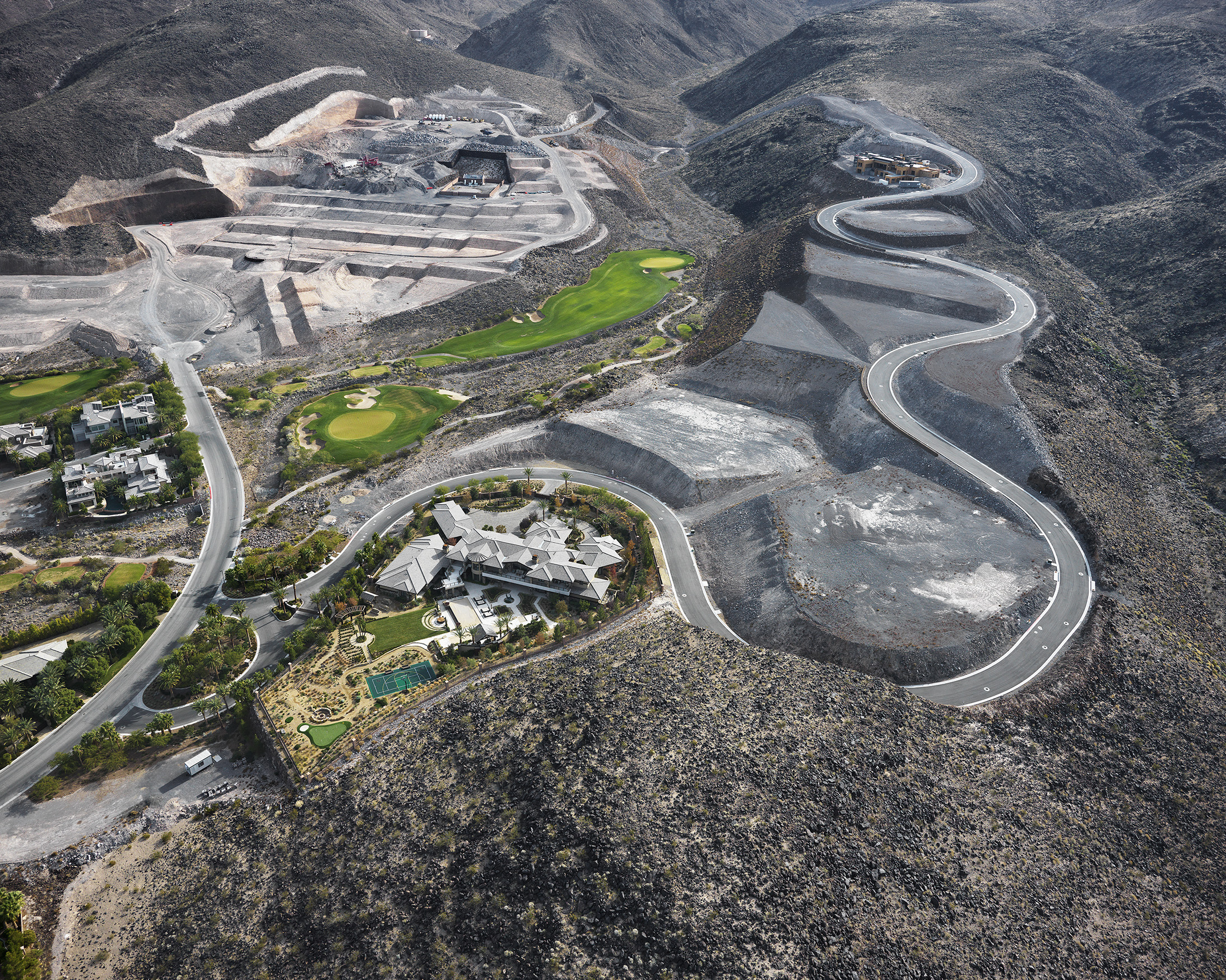
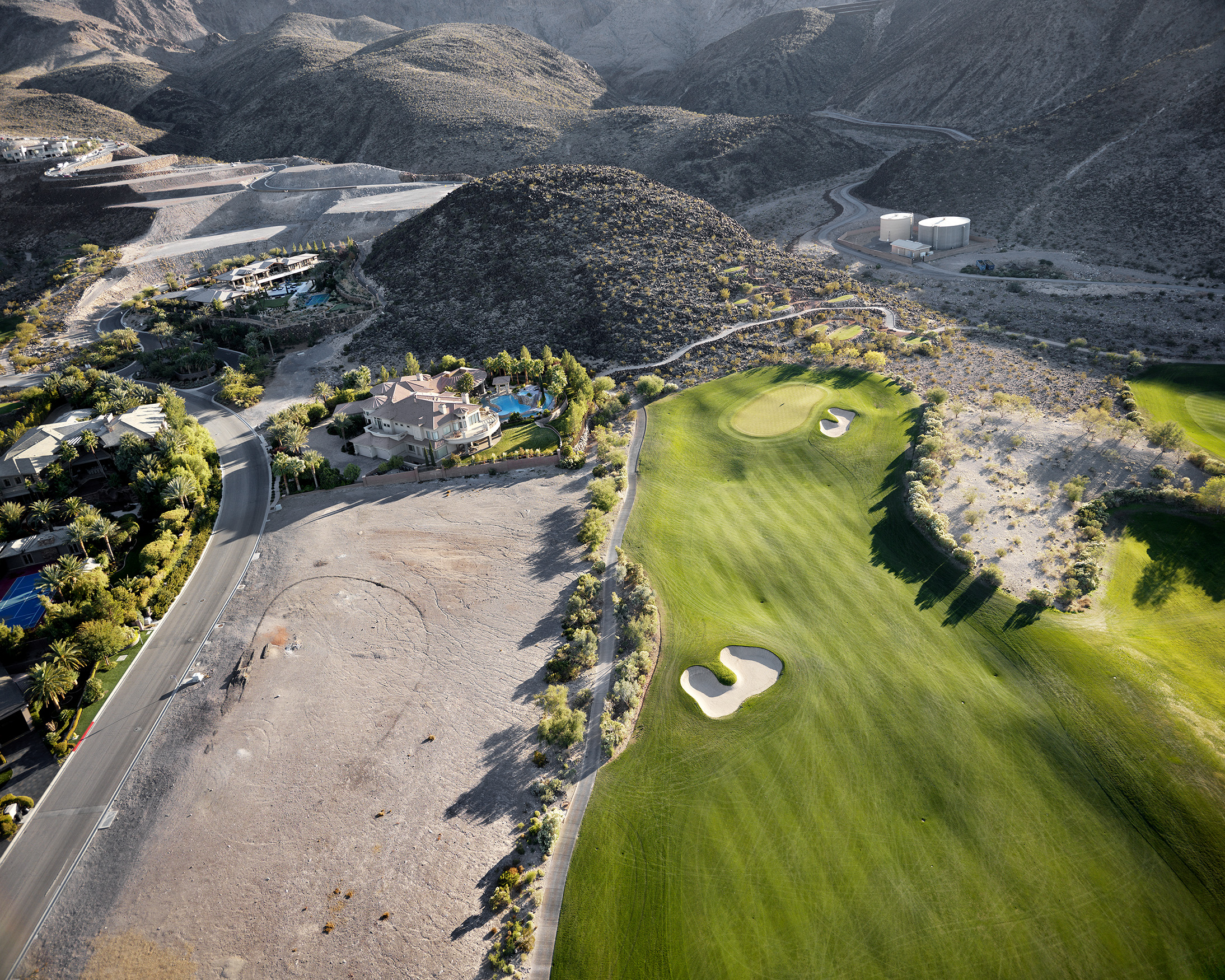
Vertical topography in desert basin cities like Phoenix and Las Vegas is coveted, and offers a stark look at the economic stratification of the current historical moment. On the southern side of the Las Vegas basin, in the town of Henderson, two developers are in the process of terraforming Black Mountain right up to the precipitous edge of the Sloan Canyon reserve. The MacDonald family shrewdly bought several square miles of the area in the 1980s; their most exclusive development, “Macdonald Highlands,” boasts as a resident Wal-Mart heiress Nancy Walton Laurie, the 106th-wealthiest American with a fortune estimated at $3.8 billion. The most exclusive “guard-gated” community in Las Vegas, however, won’t be habitable for some time. “Ascaya,” a spectacular and unprecedented 664-acre orgy of mountaintop removal above MacDonald Highlands has been dormant since 2008. Owned outright by Hong Kong billionaire and entrepreneur Henry Cheng, who spent $250 million to have the 313 lots blasted out of the mountain with dynamite from 2004 to 2008, the empty lots of “Ascaya” eagerly await Las Vegas’ next upturn, as do its many enthusiasts.
Studio-made book of 16 aerial images photographed by Michael Light from 2010-2012. Printed on Epson Enhanced Matte paper using archival Epson Ultrachrome 3 pigment inks, adhered with archival Gudy 831 double-sided pressure adhesive. Archival stability well exceeds c-print standards. Covers by John DeMerritt Bookbinding, Emeryville, CA. Edition of 10, signed on rear endpaper.

01. Bursage Loop trail looking northwest, “Del Webb Anthem” homes beyond, Henderson, Nevada; 2010
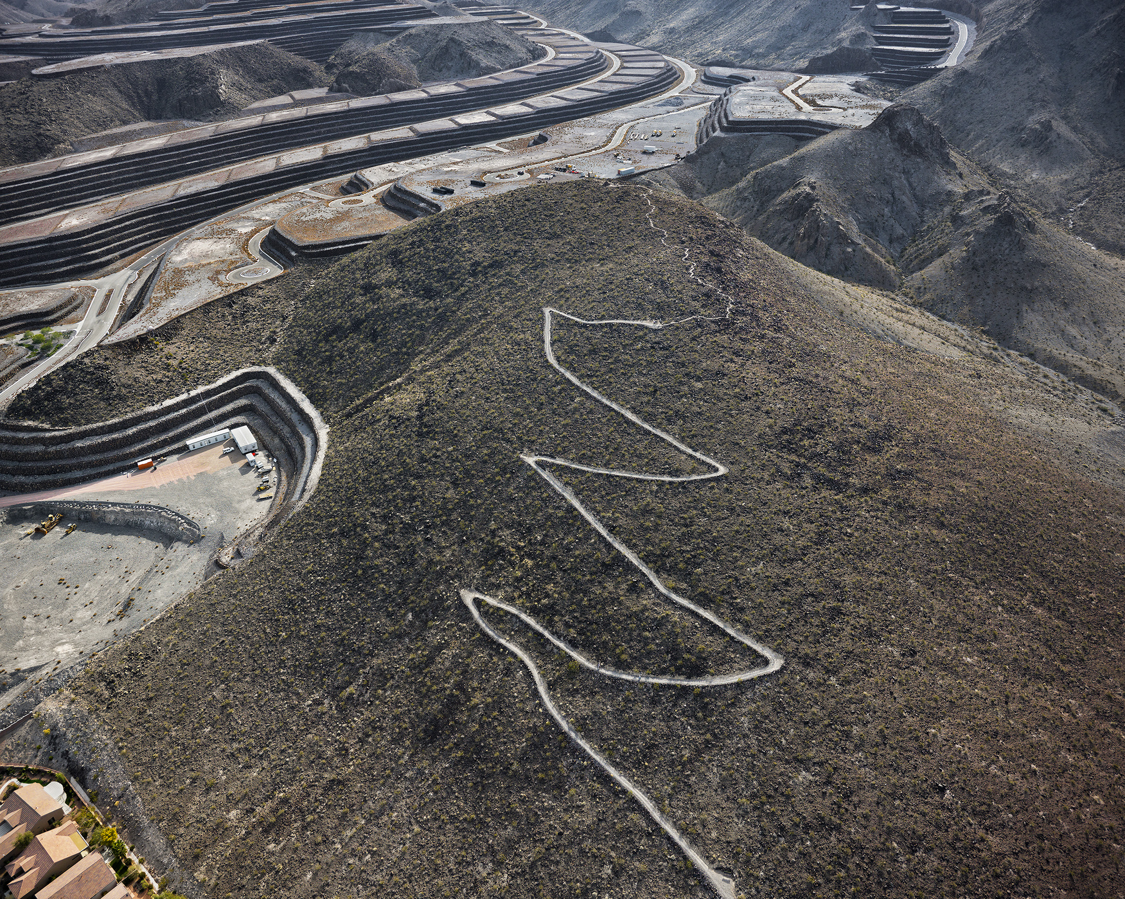
02. City View hiking trail looking southeast, unbuilt “Ascaya” lots and Black Mountain beyond, Henderson, Nevada; 2010
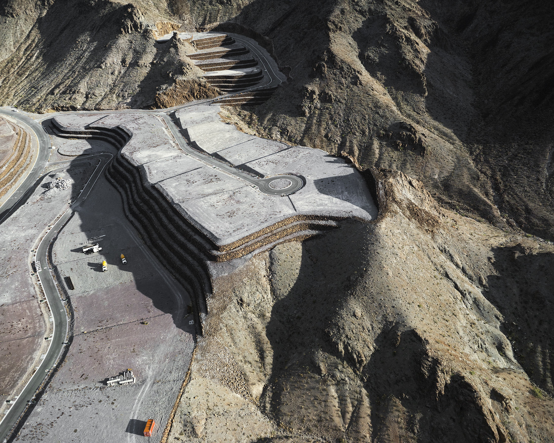
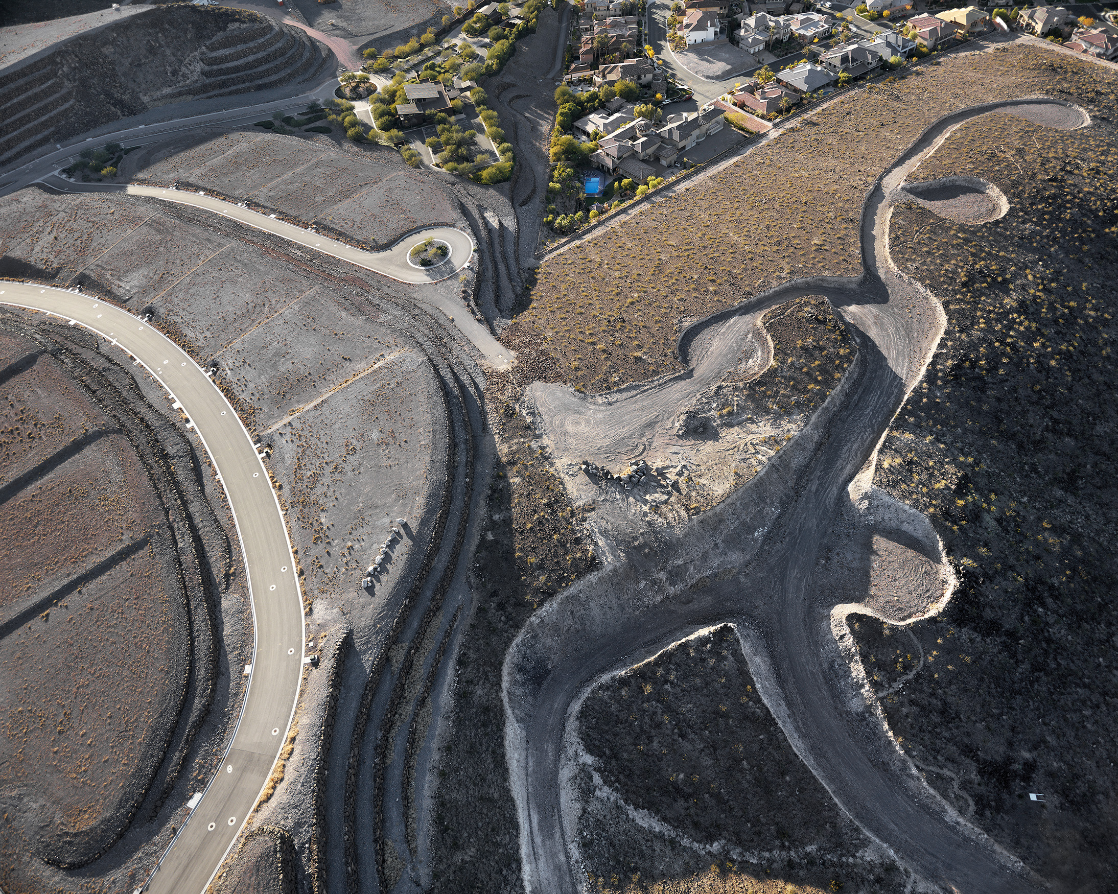
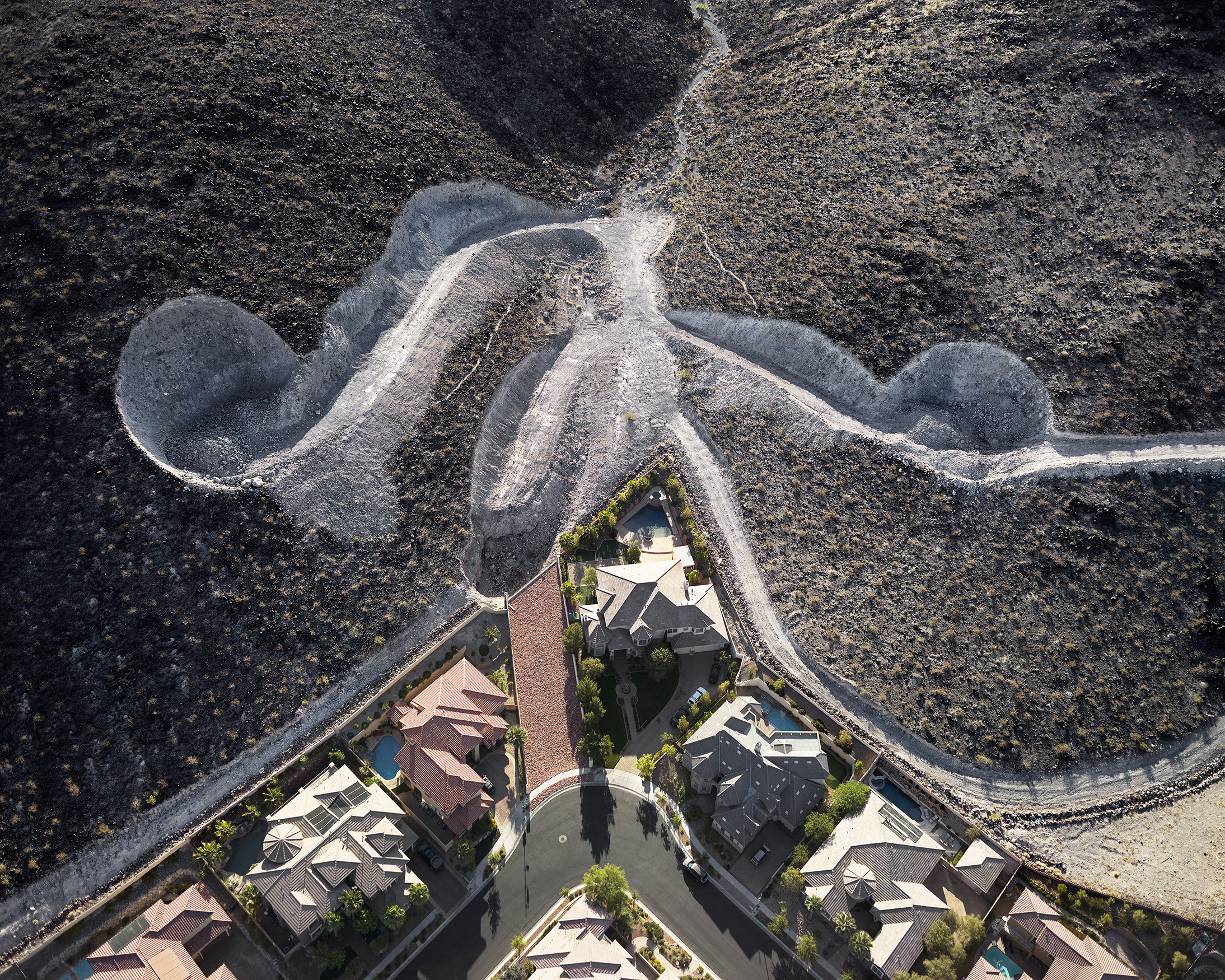
03. Unbuilt “Ascaya” lots and cul de sac looking south, afternoon, Black Mountain beyond, Henderson, Nevada; 2012
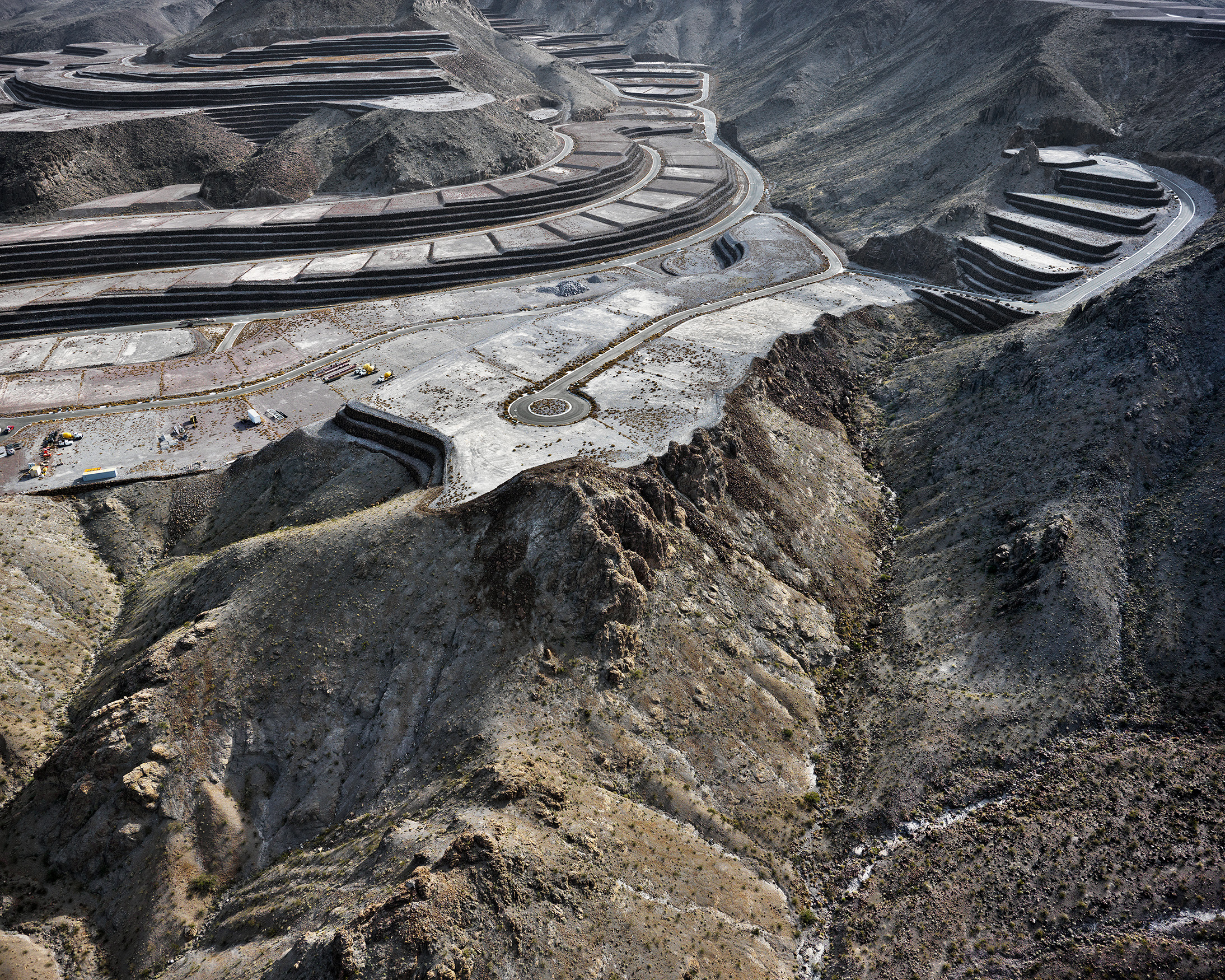
04. Unbuilt “Ascaya” lots and cul ce sac looking southeast, morning, Black Mountain beyond, Henderson, Nevada; 2010
05. Looking southwest over unbuilt “Ascaya” lots, Henderson, Nevada; 2012

06. Looking east over unbuilt “Ascaya” lots, Black Mountain beyond, Henderson, Nevada; 2010
07. Unbuilt “Ascaya” lots and cul de sac looking west, Henderson, Nevada; 2011
08. Unbuilt “Ascaya” lots looking northwest, Henderson, Nevada; 2012
09. Unbuilt “Ascaya” development looking southeast; $250 million in mountaintop removal and terracing, Henderson, Nevada; 2012
10. Black Mountain and unbuilt “Ascaya” lots looking south; Henderson, Nevada; 2011
11. Ascaya Boulevard looking south up Black Mountain, morning, Henderson, Nevada; 2012
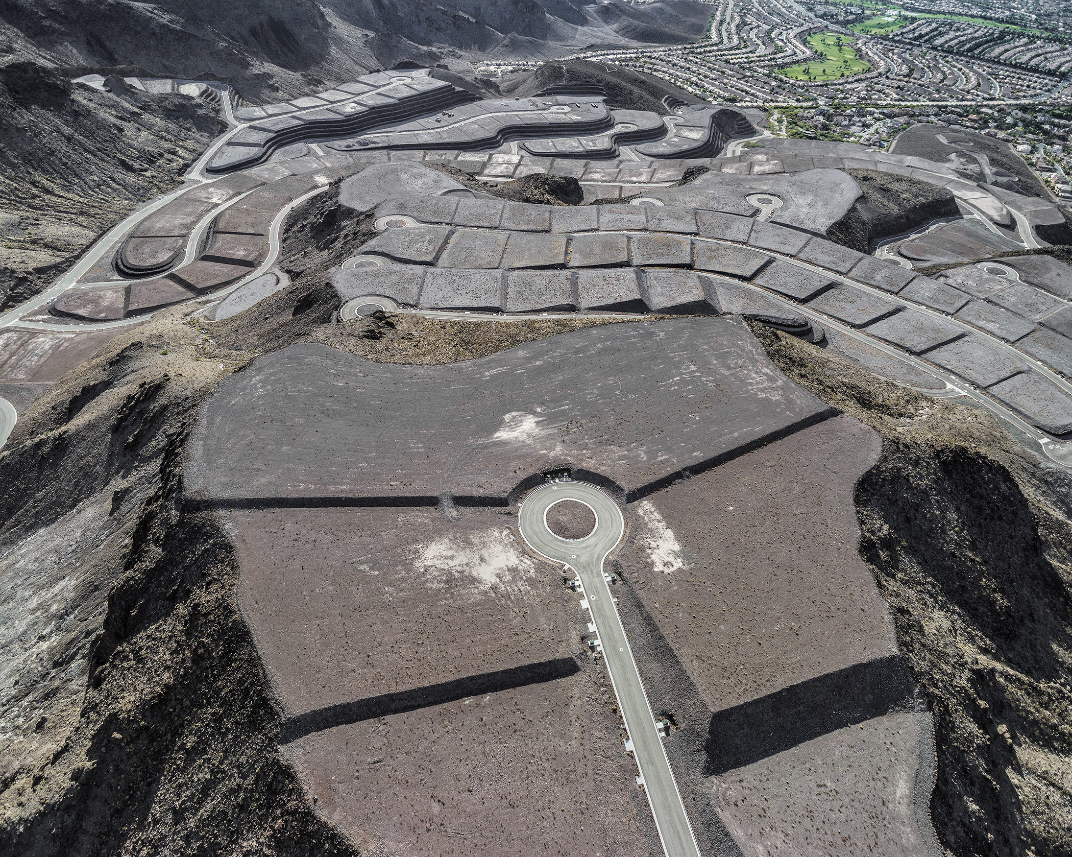
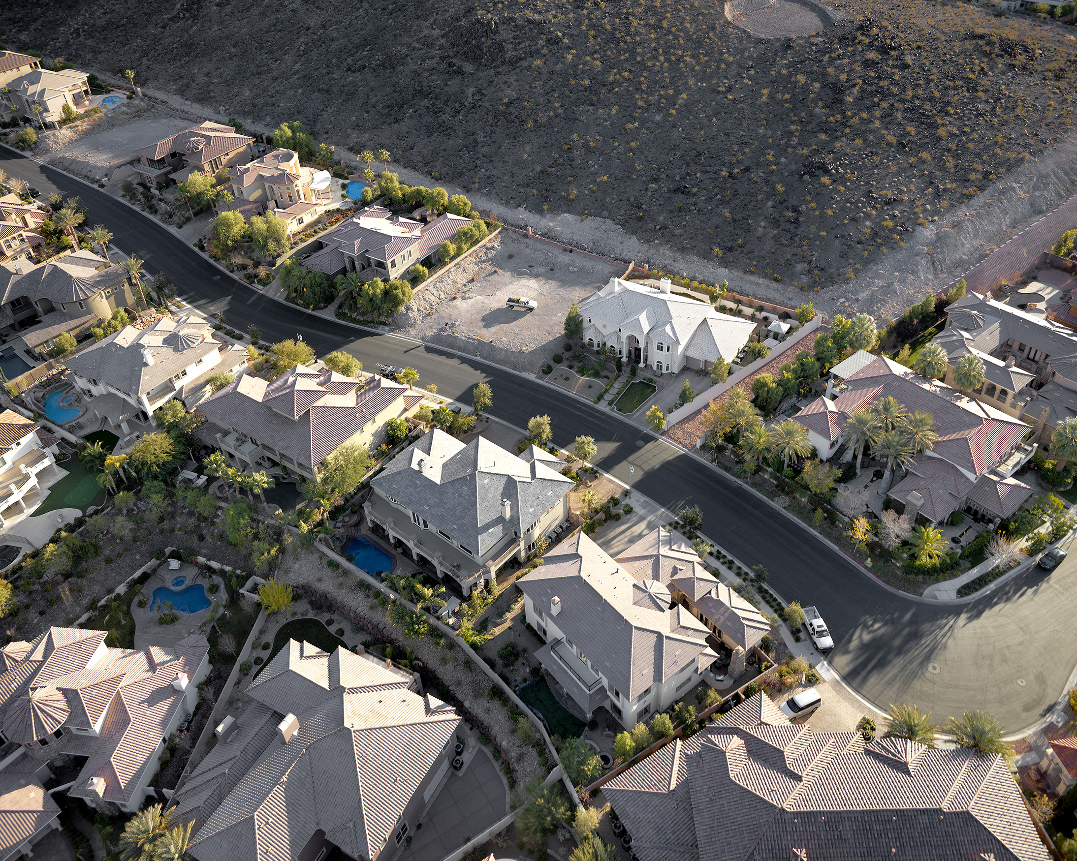
12. Unbuilt “Ascaya” lots and cul de sac looking northwest, “Sun City MacDonald Ranch” development beyond, Henderson, Nevada; 2012
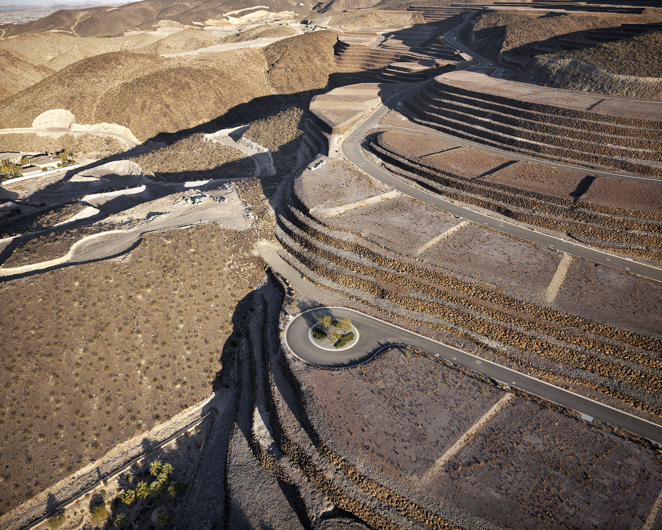
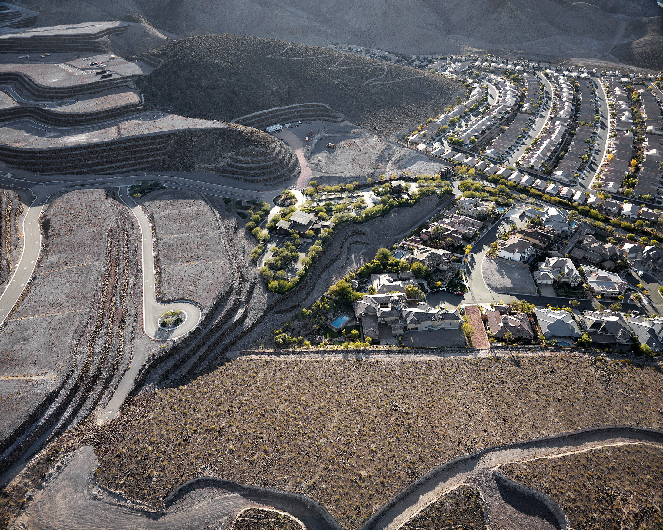
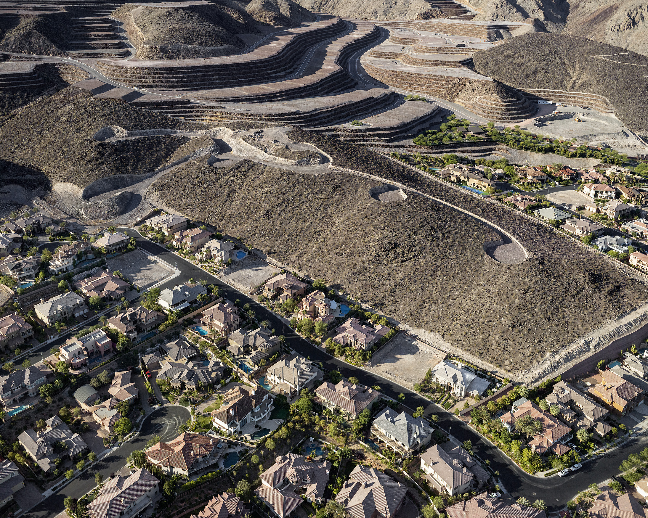
13. Edge of unbuilt “Ascaya” development looking east; foreclosed “Obsidian Mountain” development at left, Henderson, Nevada; 2011
14. “Ascaya,” foreclosed “Obsidian Mountain,” and “Roma Hills” developments looking northwest, Henderson, Nevada; 2011
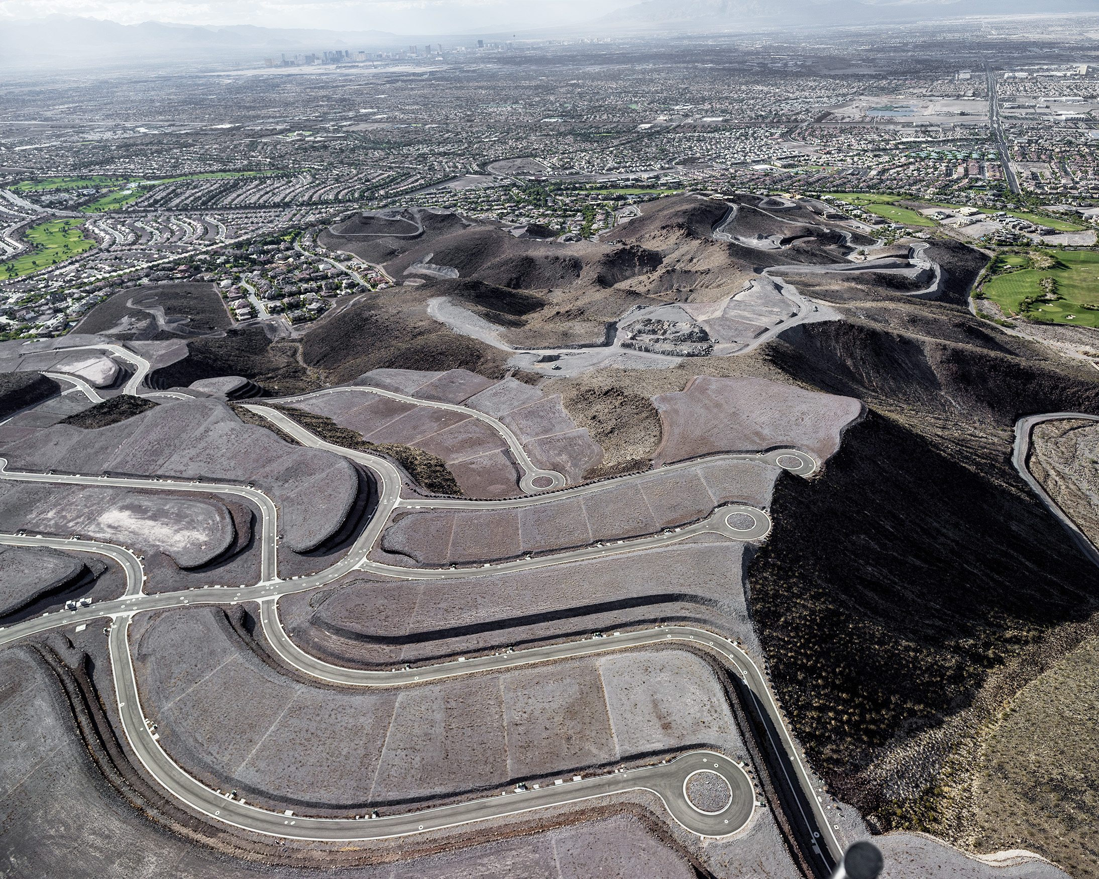
15. Unbuilt “Ascaya” lots and Cloudloft Court in foreground looking north, “Sun City MacDonald Ranch” development and downtown Las Vegas beyond, Henderson, Nevada; 2012
16. “Ascaya,” “Roma Hills,” and “Sun City MacDonald Ranch” developments looking southwest, Henderson, Nevada; 2011
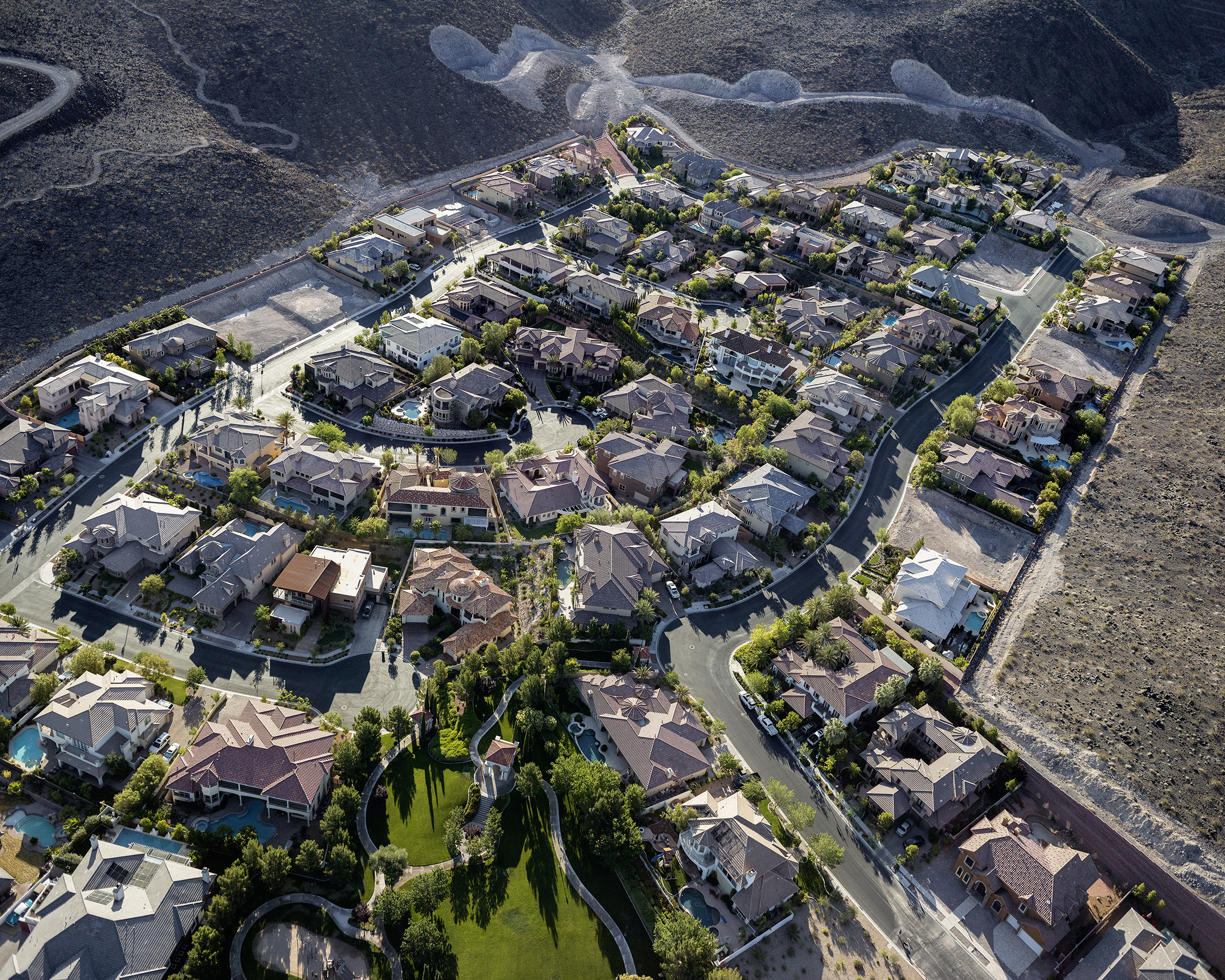
17. “Roma Hills” guard-gated homes looking east; 3000-8000 square feet each, Henderson, Nevada; 2012
18. Tozzetti Avenue and edge of “Roma Hills” homes looking east, foreclosed “Obsidian Mountain” development beyond, Henderson, Nevada; 2012
19. “Roma Hills” guard-gated homes looking south over Harpsichord Way; landscaper at work, Henderson, Nevada; 2011
20. “Roma Hills” homes and foreclosed “Obsidian Mountain” development, “Ascaya” lots beyond, looking south, Henderson, Nevada; 2012
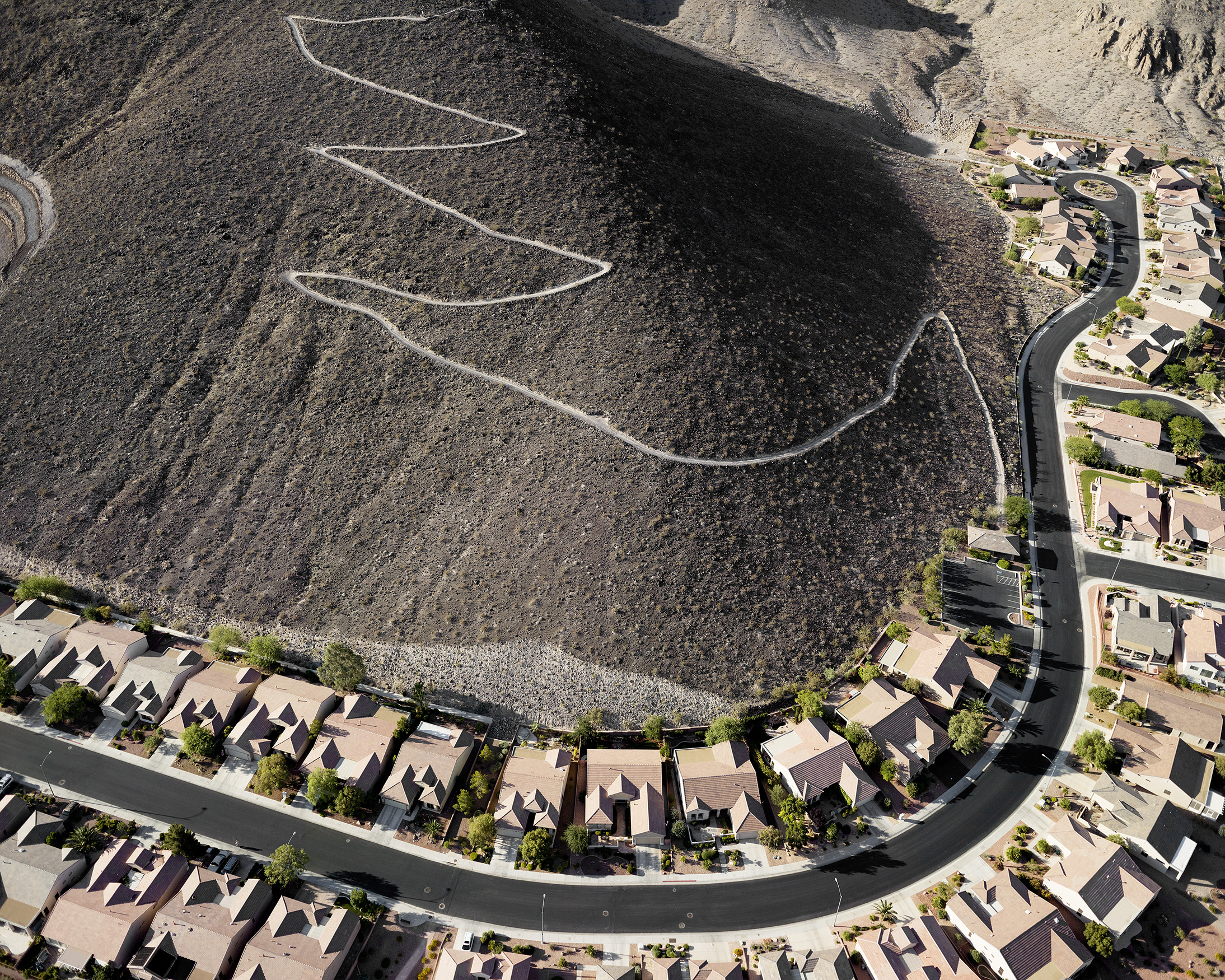
21. City View hiking trail looking southeast, “Sun City MacDonald Ranch” development below, Henderson, Nevada; 2010
22. Black Mountain looking east, Dragon Ridge golf course beyond, “MacDonald Highlands” development, Henderson, Nevada; 2011

23. MacDonald Ranch Drive and Dragon Ridge golf course looking southeast, Nancy Walton Laurie residence beyond, Henderson, Nevada; 2012
24. “Stone Mountain Ridge” to right and future “Highlander Ridge” at left, “MacDonald Highlands” development, Henderson, Nevada; 2010
25. Dragon Ridge golf course looking southeast, empty lot adjacent to Nancy Walton Laurie residence, “MacDonald Highlands” development, Henderson, Nevada; 2011

26. St. Croix street looking northwest, 14th hole Dragon Ridge golf course, “MacDonald Highlands” development, Henderson, Nevada; 2011

BLACK MOUNTAIN 2010-2012
The northernmost peak of the McCullough Range, Black Mountain, looms 5100 feet over a geologically typical Nevada basin 3000 feet below. The mountain has been popular for a long time: it’s graced with 318 prehistoric rock art panels showing some 1700 individual petroglyphs. Recently it became part of the 48,000-acre Sloan Canyon National Conservation area; a little less recently the basin below became the fastest growing city in the United States. Most recently, since 2008 and the worst American economic downturn since the Great Depression, Las Vegas has suffered the highest unemployment and home foreclosure rate in the nation. Emptied of people, it has frozen at exactly the point where its aspirational excesses were most baroque and unfettered. Las Vegas is the epicenter of a classically American strain of boom and bust capitalism. Historically the Silver State has always veered between the excess and collapse of the extractive mining industry, but air-conditioning, proximity to California, and the retirement lifestyle have brought another economy to Nevada that operates on the same maniacal principles: the habitation industry. In terms of their physical effect on the land, the extraction and habitation economies are two sides of the same coin.
Vertical topography in desert basin cities like Phoenix and Las Vegas is coveted, and offers a stark look at the economic stratification of the current historical moment. On the southern side of the Las Vegas basin, in the town of Henderson, two developers are in the process of terraforming Black Mountain right up to the precipitous edge of the Sloan Canyon reserve. The MacDonald family shrewdly bought several square miles of the area in the 1980s; their most exclusive development, “Macdonald Highlands,” boasts as a resident Wal-Mart heiress Nancy Walton Laurie, the 106th-wealthiest American with a fortune estimated at $3.8 billion. The most exclusive “guard-gated” community in Las Vegas, however, won’t be habitable for some time. “Ascaya,” a spectacular and unprecedented 664-acre orgy of mountaintop removal above MacDonald Highlands has been dormant since 2008. Owned outright by Hong Kong billionaire and entrepreneur Henry Cheng, who spent $250 million to have the 313 lots blasted out of the mountain with dynamite from 2004 to 2008, the empty lots of “Ascaya” eagerly await Las Vegas’ next upturn, as do its many enthusiasts.
Studio-made book of 16 aerial images photographed by Michael Light from 2010-2012. Printed on Epson Enhanced Matte paper using archival Epson Ultrachrome 3 pigment inks, adhered with archival Gudy 831 double-sided pressure adhesive. Archival stability well exceeds c-print standards. Covers by John DeMerritt Bookbinding, Emeryville, CA. Edition of 10, signed on rear endpaper
Black Mountain 2012